 This is the land of murky water, at least right now. My lowest visibility swim yet, if not for a family fun plan I would likely have stayed out of the water. But then again, spring plankton blooms are a part of life here, so why not swim through a soupy spring day in the Sound?
Today's low tide is -3.4 feet, one of the lowest tides of the year. With today's high of 11.8 at 6:52 pm, that's a tidal range of 15.2 feet in just over 6 hours. Wow.
My wife and kids dropped me off at the north end of my swim, Crystal Springs Rd by Baker Hill Rd. The plan is for me to swim just over half a mile to the Point White pier, where they'll be looking for interesting things exposed by the super low tide and playing in the water. Kids seem to swim in any water, even 51F, it's amazing. I remember those days, but it hardly seems real since I only get in this water with a lot of rubber on my body.
The plankton is thick, part of the time I can't see my fingertips with my arms extended in front of me. I watch above the surface or swim with one arm ahead of me at all times to avoid running into something.
 When I arrive at Pt. White pier, there are my two kids frolicking along with some friends from the hood (left). That's my 7 year old daughter in the green shirt and my 4 year old son in the orange shirt, and their friends next to them. The adults are smartly standing at the edge of the cold water, watching.
air temp: 58F
water temp: 51F
May 24, 2009, 11:30 am, sunny
wind variable, 0-5 mph
extremely low tide, slack (-3.4 feet)
visibility 1-5 feet
today's distance: 0.62 mile
total so far: 37.17 miles
notables:
algae bloom
extremely low tide, excursion 16 feet
I get in at Crystal Springs Rd, and immediately realize this is a low visibility swim. The shoreline is muddy brown, with visibility about 1 foot. Further offshore, I can see up to 5 feet but I can't see the bottom clearly anywhere. It's a foggy blur through the soup. I opt for swimming out of the gloom, even where I can't see the bottom.
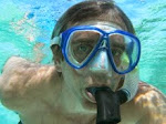
 "Where am I?" (right) I do a few dives just to see what's on the bottom, and find myself in 10 feet of water above some amazingly colorful starfish on a big boulder. No hope for a photo, except a green cloudy view of the blogfish.
 When I pull out of the water, it's great to have a greeting, and spend an hour poking through the algae and sand, digging hopelessly after retreating geoducks, looking at great critters, and generally having ocean fun. Here's a picture of my wife standing by Pt. White pier (left), the water reaches within a few feet of the dock on a high tide.
 The mussel crust on the pilings is just one of the interesting sights (right).
View Swim Around Bainbridge in a larger map



 Posts


