 Nice scenery on the beach here on Battle Point. Unbelievable Pacific madrone tree (left), with the bark peeled off (normal) and a spiral pattern in the wood.
  Also a very pretty lagoon (right). I swam this stretch on a super low tide, -2.5 and the day's high was 11.4 making a 14 foot tidal range. Clam diggers were out, I must have seen 10. That's the most beach traffic for any of my swims, and everyone was quite nice.
 Interesting, one beachgoer had grown up on this beach and he said that beach use has gone down over the years, it used to be that there were many more people out on a nice day. Sad, I wonder if access is getting tougher? It was warmer today, making the swim and exit a bit more comfortable.
I was followed by 2 harbor seals today, one was smaller and maybe a young seal.
air temp: 60F
water temp: 48F
April 29, 2009, 4pm, partly sunny
wind from south 0-5 mph
very low tide, slack
visibility 2-8 feet
today's distance: 1.07 mile
total so far: 33.35 miles
today's notables:
plankton bloom
sand dollars
sand flats
crabs
2 harbor seals
I park at a friend's house and walk down the shared private beach stairs to what will be my exit point. Access is a problem here on Battle Point. It's warm (60F) and the beach is long on this very low tide, and it's not at today's maximum low yet. Wow.
 Walking north on the beach to my entry point, about a mile, I can see it in the distance, the channel marker at the tip of Battle Point. I find a fish head on the beach, looks like a lingcod head (right). Also the madrone tree and lagoon shown above. A nice walk.
  I find some huge sand dollar flats spread out above the water on this low-low tide (left). That's the Battle Point channel marker visible in the distance.
 I get in at the channel marker and find the ebb tide is just ending. There was a bait of current as I started walking, but it's almost gone now. This is -2.5 feet, and the lowest tides of the year get to about -4 feet. With a maximum high of around +12 feet, that's a total of about 16 feet of tide as our maximum change. Today is a change of 14 feet in 5 1/2 hours.
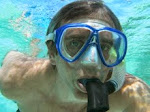
 The plankton bloom is alive and well, and here's my Mark marker of the visibility (right) a self portrait of me in the marine snow.
 I can't see a lot of underwater detail, but the swimming is fantastic. Calm, glassy water, very low tide so I'm in the subtidal zone and plowing through a plankton soup so the Sound seems very much alive.

 Here are two interesting starfish that are both in a curled up, bunched up posture. Almost looking posed.
 My progress today puts me past 3/4, I think. The map (below) looks fairly complete, I can feel the finish line coming soon. And I have very much mixed feelings about that, I want to keep going but to where?
This plankton bloom is interesting the water is much clearer near my house, but the northern channel between Bainbridge and Kitsap County just stays bloomy, thick and has low visibility. This has got to be oceanographically interesting, but I can't explain it. I'd need aerial photos and current maps or something else that I don't have. And that's not what this swim is about.
View Swim Around Bainbridge in a larger map


1 comment:
Madrona: nature is awesome! Been doing a lot of paddleboarding between Three Tree Point and Des Moines this year; even left foggy Westport yesterday to paddle glass for two and half hours in Puget Sound. Had the company of a pair of Dall's porpoises for a moment and was surprised at how close they cam considering they're so shy. Hoping to swim with you on the last day, but Jake just made the All-Star selection and has tournaments nearly every weekend in June and July.
Best,
David
Post a Comment